Satellite-Based Soil Moisture Estimation (SME)
Monitor soil moisture levels with satellite-based remote sensing technology. Optimize irrigation and enhance crop productivity.
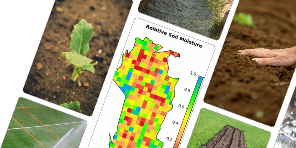
How the Service Works
KisanSAT is a satellite-based Soil Moisture Estimation (SME) service that utilizes remote sensing technology to analyze soil moisture levels across agricultural fields. The system collects data from satellite sensors that detect soil moisture by measuring microwave radiation emitted from the earth’s surface.
These readings are then processed using advanced algorithms to generate accurate soil moisture maps. By integrating Geographic Information Systems (GIS) and data analytics, KisanSAT provides real-time insights on soil conditions, enabling farmers to make informed decisions about irrigation, crop selection, and water resource management.
Benefits of the Service
Enhanced Crop Planning: Helps determine the best-suited crops for the current soil moisture conditions, reducing crop failure risks.
Efficient Water Management: Optimizes irrigation schedules to reduce water wastage and improve efficiency.
Increased Yield and Productivity: Precise soil moisture data enables better irrigation strategies, leading to healthier crops.
Cost Savings: Reduced water and energy usage for irrigation lower operational costs for farmers.
Sustainability: Conserves water resources and prevents over-irrigation for more sustainable farming.
Risk Mitigation: Monitors soil moisture trends to anticipate drought conditions and take preventive measures.
Procedure to Use
Registration: Farmers must sign up for the service via the KisanSAT mobile application.
Field Mapping: Users input their field location or select their farm area on the digital platform to receive specific soil moisture data.
Data Collection & Processing: KisanSAT continuously collects satellite data and processes it using remote sensing techniques.
Soil Moisture Reports: Farmers receive real-time soil moisture maps and reports through the mobile app or web portal.
Decision Support: Farmers can decide on suitable crop types, adjust irrigation schedules, and implement effective water management strategies based on the data.
Continuous Monitoring: Regular updates help farmers track soil moisture changes and refine agricultural practices accordingly.